A 1918 Map Gives Us a Glimpse of Justin’s Past
When we’re digging into the history of our great area, we come across some pretty interesting things. Sometimes it’s an old photograph, sometimes a newspaper clipping—and every once in a while, it’s a map.
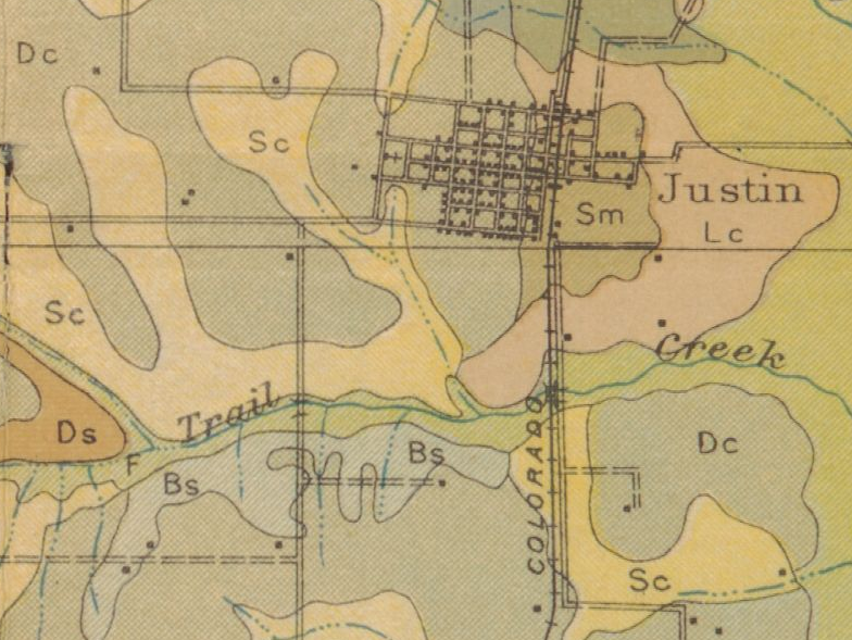
Today, we’re taking a look at a 1918 soil map of Denton County that gives us a fascinating glimpse of what Justin looked like more than 100 years ago.
The map was created as part of a soil survey of Denton County, but it ended up documenting much more than just soil. It shows roads, railroads, communities and structures, giving us a snapshot of the area as it existed in 1918.
Justin in 1918
Look closely at Justin on the map and you may notice something familiar.
Much of the town’s basic layout is still recognizable today. The map appears to show about seven streets running north and south and eight running east and west through town.
Of course, Justin has changed quite a bit since 1918. Many of the buildings shown on the map are long gone, but the little dots and symbols give us clues about where homes, schools, churches and other structures once stood.
And one spot really caught our attention.
Could That Be the Gaston House?
Southwest of town, there appears to be a structure that may be the Gaston House, the historic home the Justin Heritage Foundation is working to preserve.
We can’t say with absolute certainty that the structure shown on the map is the Gaston House without additional documentation, but it’s an interesting possibility—and exactly the kind of detail that makes historic maps so much fun to explore.
A Map of More Than Just Justin
The map actually covers much more than our little corner of Denton County.
Because it was created as a countywide soil survey, the larger map also includes communities such as Ponder, Roanoke and Krum, along with the roads, railroads and other features that connected them.
It’s pretty amazing to think about what these communities looked like in 1918.
There were no modern highways, sprawling subdivisions or rows of shopping centers. Instead, these were small communities connected by roads and rail lines and built around the people who called them home.
And yet, more than a century later, some of the original street patterns are still recognizable.
A map created to document the soil ended up preserving a little piece of our history, too.
That’s one of the things we love about looking back at Justin. You never know what you’ll find hiding in an old document—and sometimes, a simple map can tell us quite a story.
Want to Explore the Map Yourself?
We found this piece of Denton County history through The Portal to Texas History, a wonderful digital collection of historic photographs, maps, documents and other primary sources from across Texas.
Source: United States Bureau of Soils, Soil Map, Texas, Denton County, 1918. Courtesy of the University of Texas at Arlington Library and The Portal to Texas History, University of North Texas Libraries.